North Coast Rail Trail Project Construction Updates

The RTC is currently constructing the North Coast Rail Trail Project, a 7.5-mile multi-use bicycle and pedestrian trail proposed to extend along the railroad corridor from Wilder Ranch State Park in the south to Davenport in the north in unincorporated Santa Cruz County. The project comprises the majority of Segment 5 of the larger Monterey Bay Sanctuary Scenic Trail (MBSST) Network.
Construction updates, including any road or highway closures or other activities that may impact traffic, will be posted here.
Construction estimated to be completed Fall 2026.
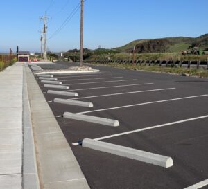
Panther (Yellowbank) Beach Parking Lot Now Open
The new paved parking lot at Panther (Yellowbank) Beach opened in April 2026 for public use in advance of completion of the full North Coast Rail Trail. The new parking lot includes accessible and multimodal parking, new restroom facilities, and a plaza with bike racks and benches.
The ribbon cutting ceremony has been postponed (originally scheduled for May 20). New date to come.
Davenport Informal Parking Area Temporarily Closed
The informal parking area on the coast side of Highway 1 near the town of Davenport temporarily closed for approximately six months beginning in early May to allow for construction of the North Coast Rail Trail, associated parking lot improvements and a new formal pedestrian crossing of Highway 1. Construction activities include, but are not limited to, grading and paving the area into a formal parking lot, utility installation, and installation of signage and amenities. One way traffic controls may be in place during active construction in the vicinity of the project area.
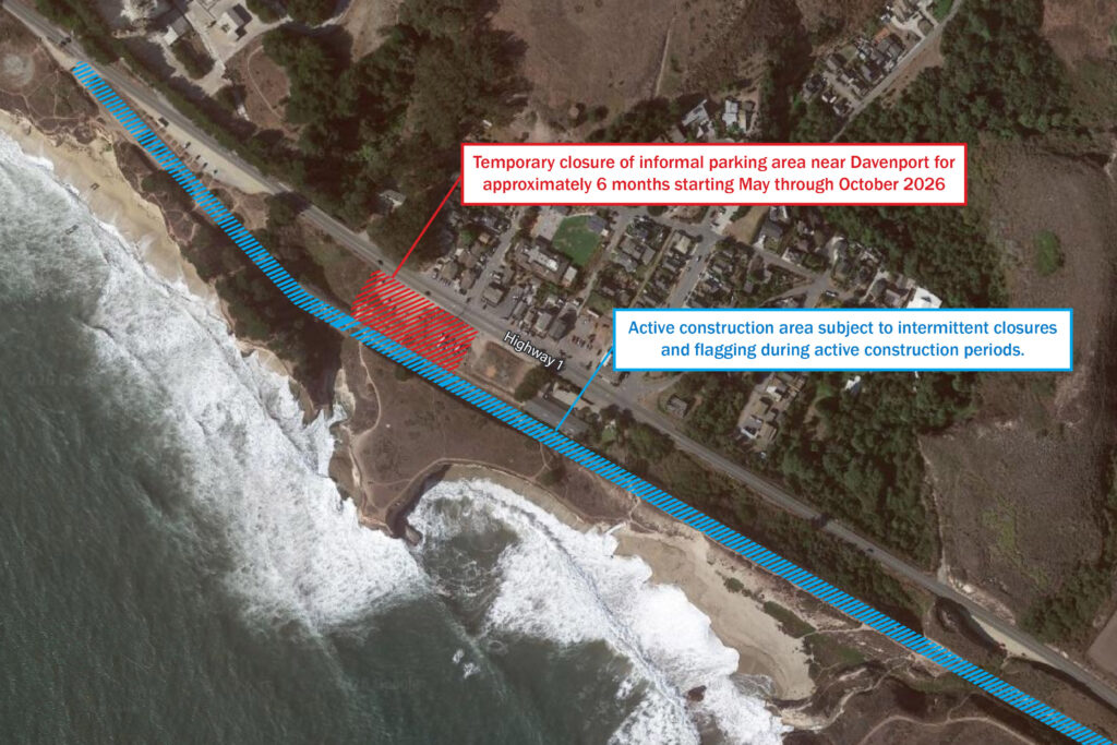
During the temporary closure, coastal access from Highway 1 where the new parking lot is under construction will not be available and access from alternative locations may be limited during active construction periods.
About the North Coast Rail Trail
The North Coast Rail Trail is a 7.5 -mile multi-use bicycle and pedestrian trail extending along the Santa Cruz Branch Rail Line corridor from Wilder Ranch State Park in the south to Davenport in the north in unincorporated Santa Cruz County. The project comprises the majority of Coastal Rail Trail Segment 5 of the larger Monterey Bay Sanctuary Scenic Trail (MBSST) Network.
In addition to constructing the new bicycle and pedestrian trail, the project includes new paved parking lots and restrooms at Panther/Yellowbank Beach and in Davenport, improved access to the parking lot at Bonny Doon Beach, and a pedestrian crossing of Highway 1 in Davenport. Construction of the North Coast Rail Trail and associated parking lot improvements began in June 2024 and is expected to be completed in fall 2026.
The Santa Cruz County Regional Transportation Commission, in coordination with Federal Highway Administration Central Federal Lands, is implementing the North Coast Rail Trail. Project partners include California State Parks and the County of Santa Cruz. The contractor on the project is Joseph J. Albanese Inc. based in Santa Clara, California.
The project is funded through state and federal grants, Measure D, and from the Land Trust of Santa Cruz County and the California Coastal Conservancy.
For more information on the North Coast Rail Trail project, click here.
Subscribe to our Mailing List
Latest news and up-to-date info delivered to your inbox
Report a Hazard
Notify us of obstacles or hazards that may inhibit travel.